Superfloods
Season 52 Episode 18 | 53m 28sVideo has Audio Description, Closed Captions
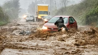
Find out why deadly flash floods are on the rise and how we can protect ourselves from them.
Recent deadly flash floods have wreaked havoc in the US and beyond. Explore why dangerous floods are on the rise and what can be done to protect more lives when they strike.
See all videos with Audio DescriptionADProblems playing video? | Closed Captioning Feedback
Problems playing video? | Closed Captioning Feedback
National Corporate funding for NOVA is provided by Carlisle Companies and Viking Cruises. Major funding for NOVA is provided by the NOVA Science Trust, the Corporation for Public Broadcasting, and PBS viewers.
Support provided by:


Superfloods
Season 52 Episode 18 | 53m 28sVideo has Audio Description, Closed Captions
Recent deadly flash floods have wreaked havoc in the US and beyond. Explore why dangerous floods are on the rise and what can be done to protect more lives when they strike.
See all videos with Audio DescriptionADProblems playing video? | Closed Captioning Feedback
How to Watch NOVA
NOVA is available to stream on pbs.org and the free PBS App, available on iPhone, Apple TV, Android TV, Android smartphones, Amazon Fire TV, Amazon Fire Tablet, Roku, Samsung Smart TV, and Vizio.
Buy Now

NOVA Labs
NOVA Labs is a free digital platform that engages teens and lifelong learners in games and interactives that foster authentic scientific exploration. Participants take part in real-world investigations by visualizing, analyzing, and playing with the same data that scientists use.Providing Support for PBS.org
Learn Moreabout PBS online sponsorship♪ ♪ NARRATOR: September 2024.
Torrential rain hits North Carolina, triggering flash floods that surge down valleys... MAN: Holy... NARRATOR: ...and destroy buildings.
MAN: It just ripped it in half.
TRISHA PALMER: Nobody in this part of the country has ever seen anything like this before.
It was devastating.
(thunder rumbling) NARRATOR: One month later, in Spain, a massive flood hits Valencia.
ANDRIES KLARENBERG: Everything was flooded with three feet of water, which was pushing cars down the streets, into buildings.
MAN (speaking Spanish): NARRATOR: The flood kills more than 200 people.
HANNAH CLOKE: Something went wrong in this flood.
We know that the flood forecasting and warning system didn't work as it should have done.
NARRATOR: Then in Central Texas, on the 4 of July 2025... ...deadly floods kill over 130 people.
(rushing water) Are flash floods becoming more frequent?
MAN (speaking Spanish): NARRATOR: And more devastating?
There was a cascading and compounding effect of this storm which I fear is a harbinger of things to come.
NARRATOR: What can we do to protect ourselves from these deadly inundations?
MAN (speaking Spanish): NARRATOR: "Superfloods," right now on "NOVA."
♪ ♪ ♪ ♪ NARRATOR: On the 4 of July 2025, an intense thunderstorm in central Texas generates floods that kill more than 130 people, including at least 39 children.
It's the deadliest inland flooding in the United States in nearly half a century.
But this shocking disaster isn't an isolated event.
In the preceding 12 months, two other record-breaking storms also produced devastating floods: one in North Carolina, the other in Europe.
Altogether, the three storms leave over 450 people dead.
What can we learn from these disasters to better protect us in the future?
(woman shouting in Spanish) ♪ ♪ Asheville, North Carolina.
It's a popular tourist destination.
Around 14 million people visit the city every year to enjoy its vibrant arts and culture... ...historic buildings... ...and spectacular mountain scenery.
Asheville's location, over 250 miles from the coast and 2,000 feet up in the Blue Ridge Mountains puts it far from the storm surges of Atlantic hurricanes.
Which made many people think it was relatively safe from extreme weather.
(fishing line whizzing) But that all changed in the autumn of 2024.
♪ ♪ Wednesday, September 25.
Torrential rain pummels North Carolina, and it looks like it's about to get worse.
For eight days, meteorologists have been monitoring a weather system coming in from the Gulf.
PALMER: By midday Monday, we had what we call a potential tropical cyclone.
Nothing is actually formed, but something is going to form.
And already then we were talking about significant heavy rainfall.
NARRATOR: By Wednesday morning, the tropical cyclone has been named Helene and grown into a hurricane.
Its predicted track puts it on a course toward western North Carolina-- and Asheville.
The city sits at the junction of two rivers: the French Broad and the Swannanoa.
On Wednesday afternoon, the National Weather Service issues a worrying forecast.
PALMER: We had a river forecast, and our hydrologist put in there the potential for "ruinous flooding" along the French Broad and Swannanoa rivers.
He put in there this has the potential to be "once-in-a-lifetime" flooding.
"Consider relocating" if you live along the French Broad and Swannanoa Rivers.
We were very concerned, and quite frankly, getting very scared at that point.
NARRATOR: But the trouble starts even before Hurricane Helene reaches North Carolina.
On Thursday afternoon, the eye of Helene is still 500 miles away in the Gulf, but in Asheville, after two days of heavy rain, the French Broad River is already beginning to flood.
That night, at 11:10, Helene makes landfall on the Florida coast as a category 4 storm.
Through the night, it tracks north, and in the early hours of Friday morning, dumps more rain onto Asheville and the surrounding mountains.
Eight miles east of Asheville lies the town of Swannanoa, named after the river that flows through it.
On Friday morning, the overnight rain from Helene swells the river, and it rises rapidly.
Michael Burgin is at home with his partner and 18 year-old son, when water starts flooding their street.
BURGIN: It was around 7:30 in the morning, I did get an alert on my phone saying to evacuate.
At that time, the water was about halfway up our cars outside.
So evacuating didn't seem possible.
Our idea was to go up to the attic first.
NARRATOR: But the water continues to rise.
BURGIN: We were up in the attic for a while.
The water started sloshing into the attic a little bit, and we didn't want to get trapped.
So, we decided to swim down into our kitchen.
NARRATOR: With water nearly up to the ceiling, they try to escape through the windows.
BURGIN: We were going up and getting air and then swimming down and trying to get the windows open.
And neither one of them would budge.
And then eventually my son was able to break the window open.
We swam through the window and then got up on our roof.
♪ ♪ NARRATOR: 14 miles downstream, the floodwater flowing down the Swannanoa, reaches Asheville.
♪ ♪ CHRIS FABER: I was on a corner unit that basically looked right up the river.
Early afternoon, mid-afternoon is when it, it started rising a lot faster.
When it started to flood the first floor apartments, everybody on the second floor was like, "Oh man, like, that's crazy."
And then it hit the second floor.
(on camera): Oh, my god!
(voiceover): It kept coming and kept coming.
At first it was just random debris, you know, litter, trash, or some tires, street signs.
By 1:00 or so, we started to see box trucks, and shipping containers, and really quite large stuff.
♪ ♪ We could see these things coming a ways away, and it just felt like slow motion.
It literally folded a giant shipping container, like tin foil.
It just wrapped around it.
Unbelievable.
It was pretty terrifying because everything looked like it was going to hit us, and then kind of last minute, it would whoosh its way out into the river.
(on camera): Oh, come on baby, miss us.
(voiceover): Certainly, the scariest one was seeing entire buildings coming down the river.
NARRATOR: This isn't just a roof; this is the entire Asheville Tea Company building.
WOMAN: It didn't hit us.
FABER: Holy... ...it just ripped it in half.
♪ ♪ NARRATOR: Upstream, in Swannanoa, floodwater continues to pour through Michael's neighborhood.
BURGIN: We were on the roof for a total of about three hours.
We started hearing foundations cracking, It was very surreal and very scary.
NARRATOR: Eventually, neighbors in kayaks carry Michael and his family to safety.
In the mid-afternoon, the flood reaches its peak.
All along the Swannanoa river, it has devastated communities.
On the morning of Saturday, September 28, the people of western North Carolina wake up to scenes of devastation.
FABER: It looked like a bomb had gone off.
I mean the destruction is incredible.
Overturned cars stacked on top of each other.
Incredible depth of just mud that you had to kind of really work your way to get through.
Streets that were just ripped up.
It completely changed the landscape.
NARRATOR: On Michael's street, everything is filled with mud.
BURGIN: The water went down remarkably fast.
Most things were destroyed, obviously.
It just was really upsetting.
NARRATOR: The flash floods smashed through buildings, swept away vehicles, and destroyed roads and bridges.
In the hills, the rain triggered landslides that buried homes and cut off roads.
As the search begins for the missing, people want to know: why did this happen here and now?
This was not the first time Asheville flooded.
In July 1916, the tail end of a hurricane hit western North Carolina, followed by another hurricane nine days later dumping heavy rain on the city.
The resulting flood killed about 80 people.
It became known as the Great Flood of 1916.
Despite its mountain location far from the coast, Asheville's geography actually makes it vulnerable to floods.
Parts of the city run along valleys, close to the French Broad and Swannanoa rivers... ...and the mountains around the town help generate rain.
PALMER: Western North Carolina, upstate South Carolina, it's got a unique feature called the Blue Ridge Escarpment.
The terrain rises very rapidly.
So you have this air that's being lifted up against the Blue Ridge Escarpment and as the warm air rises, it condenses and it starts raining, and it just all starts routing down from this creek to this creek to this creek.
Eventually, the larger streams start rising.
And this is where they live.
NARRATOR: This landscape helped create the Great Flood of 1916.
But the flood of 2024 was even worse.
In Asheville, the Swannanoa River peaked over five feet higher than the level reached in 1916.
PALMER: Nobody in this part of the country that's alive has ever seen anything like this before.
It was devastating.
NARRATOR: So why was this flood so extreme?
A clue comes in the form of another disaster.
On the other side of the Atlantic.
Just a month after the floods in North Carolina, a deadly storm hit Valencia in Spain.
Like Asheville, Valencia is a popular tourist destination... but the landscape here is different.
The city sits between low-lying mountains and the sea.
Rain is rare.
The ravines that run through the nearby towns are usually dry.
But when big storms occur, they have been known to flood.
October 29, 2024.
Meteorologists across Europe are growing concerned about an approaching weather system.
This was going to be an extreme event.
This was going to be dangerous, this was going to be something that was going to have a high impact for the people in the region.
By the morning of Tuesday the 29 of October, a red warning had been issued at about 7:00 A.M.
Red warnings mean that there is a danger to life.
♪ ♪ NARRATOR: On Valencia's coast, a strong wind whips up the Mediterranean sea, but there's hardly any rain.
However, inland, heavy rain is falling in the hills, and collecting in valleys.
Just south of Valencia, a ravine, called the Rambla del Poyo, runs from the mountains toward the Mediterranean.
Over half a dozen communities, including the town of Paiporta, line its banks.
More are dotted in the surrounding flood plain.
Over 200,000 people live along the ravine.
♪ ♪ Shortly after 2:00 P.M.
local time, water flowing down the Rambla del Poyo reaches the town of Paiporta.
It carries a wave of debris.
Within a few minutes, the dry ravine becomes a powerful, fast-flowing river.
In the afternoon, the rain in the hills intensifies rapidly.
BENTLEY: During the height of the storm, one location recorded 771 millimeters of rain, which is about two and a half feet of rainfall, falling over a space of 14 hours.
NARRATOR: Shortly after 5:00 P.M., flash flooding engulfs a town near the top of the ravine.
At 6:28 P.M., in Paiporta, the river overflows its banks and rapidly floods the streets.
KLARENBERG: All the neighbors, in the entire area, started bringing their cars up out of the underground parking.
That was very strange.
NARRATOR: Residents here know what will happen if the river floods basements.
(horns honking) In towns along the river's banks, they race to save their cars.
KLARENBERG: There was a lot of noise.
People shouting.
Every spare meter of pavement, courtyard, grass was filled with the cars from the neighborhood.
DANIEL BURGUET (speaking Spanish): NARRATOR: The storm that devastated the communities around the Valencia region was unprecedented, breaking the record for the most rain to fall in Spain during a 12 hour period.
(thunder rumbling) What caused so much rain to fall in such a short time?
The answer is a weather system meteorologists call a "cut-off low."
A cut-off low can form when an area of cold, low pressure air gets cut off from the flow of the jet stream.
This high altitude rotating mass of low-pressure air can draw in moist air from below.
The fact that they are cut off from the main flow in the atmosphere means that they sit in one location and pump moisture into the same region for several hours to days, even up to a week.
NARRATOR: When cut-off lows interact with a plentiful supply of moist air, such as a warm ocean, they can become dangerous.
That summer, the Mediterranean sea reached record high temperatures.
SHEPHERD: You have cold air in this cut-off low, but the Mediterranean waters are quite warm.
That leads to a very unstable atmosphere that can produce rising air, condensation, and a lot of rainfall ultimately.
NARRATOR: Beneath the cut-off low, warm, moist air at the surface rises rapidly, drawing in more warm air, full of water vapor, from the Mediterranean.
This rapid uplift generates huge thunderstorms.
(lightning strikes, thunder rumbling) SHEPHERD: When you have sustained moisture flow and the dynamics associated with a cut-off low, that leads oftentimes to extreme rainfall.
NARRATOR: In North Carolina, the heavy rain that pummeled Asheville in the days before Hurricane Helene arrived was also caused, in part, by a cut-off low.
SHEPHERD: The convergence of many factors produced a rainfall machine.
One of the factors with this particular case was a cut-off low.
The way that low was situated, it allowed moisture to flow into parts of Georgia and North Carolina essentially creating a funnel of moisture feeding these rain storms.
♪ ♪ NARRATOR: While Hurricane Helene was developing in the Gulf, the cut-off low formed over Western Tennessee.
This low-pressure system sucked in air, laden with water vapor, from the Gulf and Atlantic.
As this rose over the Blue Ridge mountains, it triggered thunderstorms and torrential rain.
Meteorologists call this a predecessor rain event.
PALMER: A predecessor rainfall event is when you have rainfall that is distinctly separate from the tropical system, but it involves moisture that is being pulled up from the tropical system, so it saturates the ground ahead of the storm.
And so by the time the storm gets there, everything is set up for a disaster.
NARRATOR: On Wednesday and Thursday, before Helene arrived, the cut-off low brought heavy rain into North Carolina.
By Thursday afternoon, when Helene was still 500 miles away in the Gulf, the French Broad River in Asheville was already flooding.
But then the cut-off low did something else that helped turn a moderate flood into a disaster.
When Hurricane Helene made landfall, the winds spiraling around the cut-off low pulled the storm toward it.
Downgraded to a tropical storm, Helene barreled into the Blue Ridge Mountains and dropped even more rain onto Asheville and the surrounding area.
PALMER: In portions of the Black Mountains, we had seven to ten inches of rain leading up to Helene, and then we had over a foot of rain with Helene.
And as it just keeps raining, keeps raining, keeps raining... ...again, it just set up for, for just a horrific, horrific event.
NARRATOR: The extreme rainfall in North Carolina, Valencia, and Texas, and the floods that followed, had devastating consequences for people and property.
Three historically devastating floods in the space of a year.
Just a coincidence?
Or is a new pattern emerging?
SHEPHERD: We know that all across the United States, the rate at which rain falls is more intense.
And that's related to a basic physics understanding.
As the atmosphere warms, there's more water vapor available to the storms.
(thunder rumbling) NARRATOR: For every degree Fahrenheit that the atmosphere warms, the air can hold 3% to 4% more water vapor.
Since pre-industrial times, our atmosphere has warmed about two degrees, so it can absorb about 7% more water vapor than it used to.
This means that, in some storms, heavy rain will be more intense than in the past.
Rising sea temperatures can also add more water vapor to the atmosphere because water evaporates faster at higher temperatures.
SHEPHERD: There is certainly a relationship between warming water temperatures, perhaps in the Mediterranean or the Gulf, and the intensity and amount of rainfall in cut-off lows.
NARRATOR: The warm water in the Gulf provided the energy that raised Helene to a category 4 hurricane.
Hurricanes get their fuel from the oceans, and that's a warm ocean.
And one of the things that we're increasingly seeing is warm sea surface temperatures; marine heat waves.
And so, these storms are stronger as they're moving in and they're producing greater amounts of rainfall.
NARRATOR: In July 2025, high levels of water vapor in the atmosphere above Texas contributed to America's deadliest inland flood in nearly half a century.
Warm, moist air from the Gulf moved over central Texas, feeding powerful thunderstorms that soaked the western Hill Country with heavy rain.
Floods swept down the Guadalupe River and surrounding creeks, leaving death and destruction behind.
SHEPHERD: The Texas floods were a combination of several meteorological or weather factors.
That region is known as Flash Flood Alley.
It's close to the Gulf, and there was ample moisture from the Gulf-- a quite warm Gulf by the way-- and you had the remnants of Tropical Storm Barry that also was a moisture source.
As meteorologists, we look for moisture as a signature of potential flooding.
And moisture was at record levels.
It was certainly clear to forecasters that this was going to be a flood event.
NARRATOR: In Texas, many weather stations reported five to ten inches of rain in less than six hours.
When that rain funneled into the Guadalupe River, it rose about 26 feet in 45 minutes.
The result was utter devastation.
(wood snapping) The Texas and other recent floods may be a sign of things to come.
Recent studies indicate that, as global temperatures rise, the United States will see an overall increase in flooding; especially in the east.
And there's another problem.
As the world's population grows, more people are living in areas that flood.
We've got a lot of pressure to build new houses all of the time, and that, of course, makes it very difficult to protect those places such as floodplains, where we don't really want people living, because they can be dangerous.
Sometimes floods don't happen for, you know, a hundred years at a time, so people will build, because they think that there-- you know, there's nothing that's going to happen.
But actually, it is a dangerous place.
NARRATOR: It's a double threat.
To stay safe, it's increasingly important for people to be aware of the risks.
(buzzing) But the range of danger that floods and heavy rain present depends a lot on the terrain.
(drone continues buzzing) In the hills and mountains around Asheville, the biggest killer from Helene was landslides.
The National Oceanic and Atmospheric Administration classified the landslide deaths here as fatalities from fresh water flooding.
PHILIP PRINCE: With this type of landsliding, what we saw with Helene, water is the key ingredient.
None of what we saw happen is going to happen without a tremendous amount of water present in the soil.
(water surging) NARRATOR: Water from Helene caused this slide.
Fortunately, no one was hurt.
♪ ♪ PRINCE: It's absolutely the most acutely dangerous natural event that you see in the Appalachian Mountains, just because of the speed with which it moves.
NARRATOR: 13 miles east of Asheville, the storm left another tragedy in its wake.
In the small community of Craigtown, 13 people lost their lives when a series of landslides swept down the mountain, destroying homes.
Geologists Jennifer Bauer and Philip Prince are helping compile an inventory of the more than 2,000 landslides in North Carolina triggered by Helene's rain.
Today, they are climbing to the top of one of the Craigtown landslides to find out what started it.
Can you see anywhere that might be a ground water source up here?
Let's look under here.
NARRATOR: This slide, like most in North Carolina, was a type of landslide known as a debris flow-- a landslide made of soil, rock, other objects, and water.
So this is what, like, I don't know, three feet long?
That's a good way to concentrate a lot of ground water in one spot.
Yeah.
For sure.
NARRATOR: Debris flows often begin near the top of a mountain, where the slopes are steepest.
Rain soaking into the soil can accumulate as groundwater high on the mountain.
Underground channels can then funnel it to one spot.
This is a big hole in the ground that groundwater just comes out of, and groundwater can find its pathways through all of the loose boulders in the soil.
And probably shot out through the soil right here.
PRINCE: And with the added push from that providing almost, like, groundwater pressure underneath the ground surface, it's going to destabilize the type of soil we have here.
NARRATOR: The saturated soil here triggered a debris flow that traveled about a mile and a half before it hit Craigtown.
At approximately 25 miles an hour, that would only take about three and a half minutes.
Residents would have had little warning of what was coming.
Across the southeast, landslides were one of Hurricane Helene's biggest killers.
So, what can people do to protect themselves from them?
BAUER: Watch the National Weather Service warnings, and if there's any wording about landslides, then to not be within one of those debris flow pathways or where the landslides might start.
There are online landslide maps available.
The North Carolina Geological Survey has put some out so that people can go online and see if they're in one of these areas.
And if they are, they can then go stay somewhere safe.
NARRATOR: In Valencia, the flatter terrain, and more urban environment, created a different danger.
Here, cars became death traps.
Safety advice says you should never drive through flood water, but for some in Valencia, there was no way to escape it.
(rain pounding) KAREN LOFTUS: We were on the motorway.
It was raining very hard.
I've never been in rain quite like it.
And the traffic came to a standstill.
Then we started to see that the water wasn't going anywhere, and it started to rise up from the motorway.
After about five minutes, the water started to come in to the bottom of the car.
(water rushing) The water continued to rise to the point that our car engine did cut out.
STEVEN LOFTUS: Well, literally, the car is now floating sideways.
(thunder rumbling) NARRATOR: The force of water pressing around the car makes it impossible for Karen and her husband to open the doors from inside.
KAREN LOFTUS: Oh, god.
NARRATOR: Luckily, they had lowered the windows before the engine cut out.
KAREN LOFTUS: Within ten minutes, I was having to get out of my car window into what was a muddy, freezing cold torrent of water.
(water surging) There were cars starting to float, and some people had been able to get out and some people were still in their cars, obviously very frightened and scared.
There was a huge articulated lorry, and we just thought, "we'll just try."
And we banged on the door of this lorry, and then this wonderful Moroccan lorry driver drove us out.
♪ ♪ NARRATOR: They were lucky.
(metallic clang) Many others were not.
(indistinct radio chatter) ♪ ♪ The floods in Asheville, Valencia, and Texas were some of the worst experienced in the western world in recent years.
In North Carolina, the storm killed 107 people.
In Valencia, 228 died.
In Texas, more than 130.
Casualties like these are very difficult to prevent, because flash floods happen so quickly.
But could there have been more advanced notice, and timelier warnings to evacuate?
In the United States, much of the necessary infrastructure is already in place.
Two days before Asheville flooded, the National Weather Service computer models and forecasters accurately predicted that the flood could be as big as the Great Flood of 1916.
♪ ♪ But as the rain started to fall, they needed to forecast where flooding would occur, and when.
PALMER: During the height of the event, we had eight people here overnight, and then three of those eight were issuing flash flood warnings.
NARRATOR: To help predict floods, forecasters in the United States use a tool developed at the National Severe Storms Laboratory in Oklahoma.
The system, called FLASH, calculates where heavy rain will most likely cause a flood.
Across the country, 158 radars detect rain, and tell forecasters how much is falling.
But to predict a flood, they need to know where that water will go when it hits the ground.
JONATHAN GOURLEY: What is the condition of the land surface that the rainwater is falling on?
A little bit will be intercepted by the vegetation.
Some of it gets infiltrated in the soils.
But in many urban areas that are developed, we don't have those soils as much, and they've been replaced by asphalt and concrete and buildings, and in general, they have much less capacity to absorb some of that incoming rainfall.
♪ ♪ NARRATOR: The FLASH system contains a grid with details of the different terrain in every square kilometer of the country.
GOURLEY: To run a simulation, we have over 10 million grid points across the United States.
At every grid cell, we know the characteristics of the land surface in terms of the vegetation type, the composition of the soil, as well as the topography.
NARRATOR: The system uses this information to calculate where the water will flow and pinpoints areas at risk of flooding.
The total time FLASH takes, from detecting rain as it falls to predicting a flood, is just minutes.
GOURLEY: The worst case scenario would be about 16 or 17 minutes.
Here on this left screen is FLASH.
So, this is during the height of Helene.
FLASH is really helpful for us to determine which areas are more likely to need a flash flood warning first.
Especially at the beginning of an event.
Yellow is when we're starting to think about maybe the base flash flood warning.
The red to the purple is when we're thinking about looking at that catastrophic or flash flood emergency.
NARRATOR: For Helene, the National Weather Service's rainfall and flood forecasts were pretty accurate.
But predicting a flood is only half the challenge.
The next step is to make sure people in danger know about it.
Here, Helene revealed that the current system has a critical weakness.
The main method authorities use to inform people is to send a wireless emergency alert to their cell phones.
The system works by using the country's network of cell towers.
When there's a threat of an emergency, such as a flash flood... (thunder booming) ...response officials mark the danger zone on a map.
(beeping) They then send an alert message to the nearby cell towers.
GPS coordinates of the danger zone are encoded in the message, so modern cell phones in or entering the zone can trigger the alert, which contains a warning message advising people what to do.
PALMER: So, when we want to go to issue a flash flood warning, we use this system.
So, I can just start drawing a polygon.
And if I want to send out a Wireless Emergency Alert, it has to be considerable or catastrophic.
Once I'm happy with everything I've typed in here, I come down here to "issue all."
(click) NARRATOR: When Helene unleashed its rain, the team at this National Weather Service office issued more than 80 wireless emergency alerts for flash flooding in just two days.
But not all the messages got through.
The problem was the wind.
Hurricane Helene's winds were incredibly strong.
PALMER: As these winds were moving north, it was a cascading power failure.
Trees were going down everywhere.
(crashing) Power lines were being snapped.
So as the power grid was falling, communications were going down, just because power to the cell phone towers was failing.
Once you don't have the communications, you can no longer get the wireless emergency alerts.
NARRATOR: In North Carolina, the early forecast of major flooding, and the wireless emergency alerts that did get through, are thought to have saved many lives.
(click) In Texas, the National Weather Service also forecast the flooding.
The day before the floods, it initiated a flood watch.
SHEPHERD: We know that from a meteorological perspective, there were ample weather warnings in the days and hours leading up to the event.
There are questions about how that information was channeled into warnings and risk communication for the public.
NARRATOR: Flash floods happen so fast there is little time to take action.
Texas Hill Country was no exception.
At 1:14 A.M., the National Weather Service sent out a warning alert to cell phones in the area of Camp Mystic, a Christian girls' summer camp.
About 45 minutes later, the flood hit.
At Camp Mystic, at least 27 girls and members of staff died.
In total, the Texas Hill Country floods killed more than 130 people.
SHEPHERD: We know that there were not the type of warning systems that we often would expect in this type of complex terrain.
So, I think conversations going forward will be centered around how adequate were cell phone notifications.
Is there coverage?
Are weather radios needed?
Is some type of siren or warning system needed?
These are all questions that certainly should be asked.
NARRATOR: And not only about Texas.
(crashing) In Valencia, there were problems with both forecasting and warning people.
CLOKE: We know that when we have a good flood forecasting and warning system and that people know what to do when they receive those warnings, that lives are saved.
So something went wrong in this flood.
We know that the flood forecasting and warning system didn't work as it should have done.
NARRATOR: In Valencia, weather forecasters saw the storm coming well ahead of time, and on the morning of the flood, issued a red alert.
But their forecasts underestimated the amount of rain.
They predicted that more than seven inches of rain would fall in 24 hours.
The highest actual amount was 30 inches-- over four times as much.
GOURLEY: One of the grand challenges is predicting intense rainfall that occurs over these really small spatial scales.
We may have like a broad area where we're anticipating some heavy rain, but what does that mean?
Which city is going to be impacted?
And when I say heavy rain, is it going to be a catastrophic rainfall event that's going to annihilate the city, or is it just going to be a spring thunderstorm.
It's very difficult to distinguish those two.
(lightning crashing) NARRATOR: When the storm turned out to be one of the biggest to ever hit Spain, the emergency services were overwhelmed.
(person exclaiming, objects crashing) (helicopter blades churning) Unlike the United States, Valencia didn't have a system like FLASH to automatically predict where rain would cause floods.
Instead, it relied on more traditional methods.
Around the Poyo ravine, rain gauges in the hills sent back readings of rainfall every five minutes.
♪ ♪ On the ravine itself, a sensor situated ten miles upstream of Paiporta measured the flow of water.
When the rain increased in the afternoon, the flow in the Poyo started rising rapidly.
At 6:55 P.M., it reached 600,000 gallons per second, almost as much as the average flow of water over Niagara Falls.
Then, the water swept away the sensor.
♪ ♪ Despite all the gauges and sensors, very little of this information appears to have reached the emergency committee meeting responsible for sending out the wireless emergency alert.
(click) (inaudible shouting) At 8:11 P.M., two hours after the Poyo River first broke its banks, the cell phones of people across the province made an alarm sound and displayed a warning message.
(alarm tone) KLARENBERG: The first warning I got was after the streets had flooded.
My mobile started kind of aggressively buzzing.
Yeah, so, after... after the fact.
KAREN LOFTUS: Had we received the alert, which we did receive, four hours after the event, of course we wouldn't have traveled.
It would've been a folly to travel.
NARRATOR: Many of the victims had died before the alert was finally sent out.
♪ ♪ In Spain, an investigation is under way to find out what went wrong.
But timely warnings alone aren't necessarily enough.
In North Carolina and Texas, warning systems were not always able to get the messages through to the people at risk.
♪ ♪ National Weather Service advice is to not rely on just one technology.
If for whatever reason, whether you don't have your phones, or there's not adequate cell phone service, we need redundancy, we need other ways of communicating the threat.
NOAA weather radio is connected directly to NOAA and National Weather Service warnings, and so it will be triggered irrespective of whether there's cell phone coverage.
PALMER: While cell phone towers and cell phone communications went down, NOAA weather radio stayed up.
So, we always recommend that folks have a NOAA weather radio.
(person exclaiming, water surging) NARRATOR: The disastrous floods in North Carolina, Valencia, and Texas are a wake-up call to authorities around the world.
SHEPHERD: I'm often asked if this is a harbinger of things to come.
My response would be, it's already here.
The atmosphere has warmed, and the systems are tapping into elevated moisture supply, and we're seeing extreme rainfall events.
That's not my opinion, that's what scientific studies are showing.
NARRATOR: Across the globe, governments are taking action, not only to improve warning systems, but also to protect their citizens.
(rain pounding) In Japan, the annual number of heavy rainstorms has increased by 40% over the last 30 years.
It's a serious problem for the capital city, Tokyo.
(lightning striking) When heavy rain hits, parts of the city flood.
To channel water away from rivers that were at risk of overflowing, in the 1990s, engineers began building a massive underground flood relief system.
Workers excavated nearly four miles of tunnels beneath the city.
♪ ♪ Giant subterranean silos were designed to store some of the water, while a vast cathedral-like reservoir, 60 feet high, would hold the rest.
Yet, this extraordinary underground project is still not big enough to cope with the increased rainfall expected from global warming.
Work is now underway to double its capacity.
♪ ♪ The increased risk of flooding in many places is forcing planners and engineers to rethink their designs.
CLOKE: Often, new engineering structures that go in or the new plans that are in place are all based on the last disaster that's happened.
But what we really need to do is imagine what other types of flood might happen as well.
So that act of imagination, the act of thinking of through those scenarios of the future, is really important.
NARRATOR: In Asheville, communities are attempting to rebuild.
It looks like they're trying to reconstruct it.
We all had to leave.
There were tons and tons of mud inside the building.
The first floor, completely wiped out.
I was able to find another place to live.
Some people left and just didn't come back.
We actually still have the window that we swam out of, it's just not attached to the house anymore, but this is the amount of space we had to swim out of.
♪ ♪ It's been a struggle in a lot of ways, but we've had a lot of like really skilled workers working with us, and a lot of great volunteers.
All over the world people came to help people here.
The danger of the flood happening again is something we have to take seriously.
We've applied for the elevation program.
So, eventually, our house is gonna be basically on stilts.
♪ ♪ NARRATOR: The flood has brought this Swannanoa community together.
BURGIN: We know them all so much better now.
We just want to stay in the area and be around each other.
That's why everyone wants to rebuild.
That's why everyone wants to stay.
(water rushing) NARRATOR: Floods will always happen.
But we have the technologies to make them less deadly.
CLOKE: We're in the position now where we have good weather forecasts, and we have good flood forecasting systems.
So we should be able to provide warnings to people to make sure that they have the information they need before floods hit.
SHEPHERD: We know that we'll continue to have extreme rainfall events that will lead to flooding.
So, as we move forward, we have to think carefully about what type of warning and dissemination systems are needed-- that's a clear need in terms of risk communication in Texas and in places around the world.
♪ ♪ NARRATOR: The science is clear: with intense rainfall increasing, more frequent floods are already here.
♪ ♪ ♪ ♪ ♪ ♪ ♪ ♪ ♪ ♪ ♪ ♪
Video has Closed Captions
Preview: S52 Ep18 | 30s | Find out why deadly flash floods are on the rise and how we can protect ourselves from them. (30s)
Providing Support for PBS.org
Learn Moreabout PBS online sponsorship
- Science and Nature

Capturing the splendor of the natural world, from the African plains to the Antarctic ice.


Support for PBS provided by:
National Corporate funding for NOVA is provided by Carlisle Companies and Viking Cruises. Major funding for NOVA is provided by the NOVA Science Trust, the Corporation for Public Broadcasting, and PBS viewers.